Evidence procured during my Western Desert (of Egypt) winter 2007/08 camel-expediton throws new light on the issue of the supposed age of the first attempts towards the formation of a pool of written signs which partly, formed the basis of the Pharaonic script.
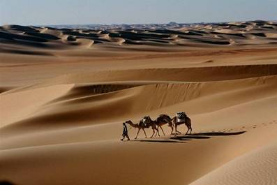
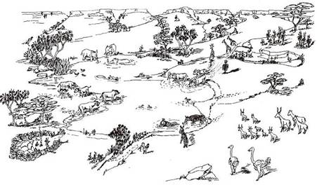
picture 1: Researching the Western Desert of Egypt by camel
(photograph by Hardy Böckli)
Egyptologists have assigned the beginning of writing in Egypt to the Naqada II period (3,600-3,000 BC). The new evidence presented in chapter I. of this paper indicates that the first tentative attempts at forming a sign system, from which the pharaonic script drew heavily, dates back to the beginnings of the Predynastic period (approx. 5,000 BC) (predating Naqada I (4,300-3,600 BC) by approx. 700 years). These roots of hieroglyphic writing were in parts, developed in the Western Desert of Egypt.
I.) Radiocarbon Datings from the “Giraffe Hunter & Nomadic Cattle-Pastoralist era”
A.) Results
Samples collected during my winter 2007/08 camel- expedition have recently been radiocarbon dated. These age determinations, apart from throwing new light on several of my propositions as published in past expedition reports on my website, also strongly urge a rethinking and modification of some of the assumptions of others.
Three datings are submitted here:
a.) decorated ostrich eggshells (2007/08-37b): BP 6,520 +/- 37 (Two Sigma Range: cal BC 5,557 – 5,378; probabilty 95,4%)
b.) ostrich eggshells (2007/08-39c): BP 6,244 +/- 35 (Two Sigma Range: cal BC 5,309 – 5,073; probability 95,4%)
c.) ostrich eggshells (2007/08-19): BP 6,492 +/- 35 (Two Sigma Range: cal BC 5,517 – 5,372; probability 95,4%)
Whilst the first two datings are from Biar Jaqub, a “lost oasis” about 60 kilometres southwest of Dakhla oasis, the third is from a site located a short distance away from a branch of the ancient Kufra Trail (KT), ie., about a third of the way from Dakhla oasis to the Gilf Kebir.
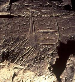
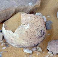
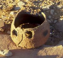
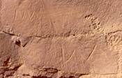
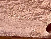
I had tentatively estimated the age of samples a.) + b.) to be around 5,500 years old (3,500 BC or slightly younger). This dating is predominantly based on the character of the motifs depicted on five ostrich egg fragments (picture 2), an exeptional find which, according to my judgement, exhibit a resemblance to the decorative art of Naqada II period (3,600-3,000 BC). However, the dating results above disabused me of such a notion.
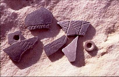
picture 2: fragments of decorative art on ostrich eggshells from a Giraffe Hunter
& Nomadic Cattle Pastoralist location in Biar Jaqub
During discussions with the head of the University Institute who conducted the age tests, it emerged that the reservoir age of ostrich eggshells found in the Nubian Sandstone environment of the Libyan desert was determined to be approximately 400 years. (For an explanation of the reservior age effect see for instance “Radiocarbon dating” in wikipedia; for details see Vogel et al in: Radiocarbon 43 (2001) pp. 133-137 or www.C14archaeology.ethz.ch/ProgramAbstractsMarch14.pdf) This effect causes radio carbon dating of the three samples to appear about 400 years older than they actually are. However, even if the above values are adjusted, the new average time spread spanning the period of cal BC 5,157-4,673 would not allow a link between the three samples and Naqada II. Irrespective of this outcome the following remarks will be based upon the corrected value.
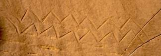
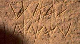
The above (reservoir effect corrected) radiocarbon date (cal BC 5,157-4,673) throws new light on the issue of the supposed age of water mountain symbols (pictures 3 - 6) as well as on other “proto-hieroglyphs” found during my wanderings in Biar Jaqub.
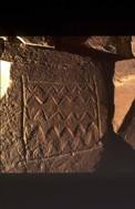
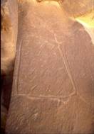
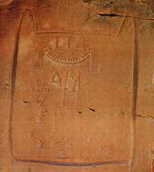
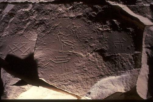
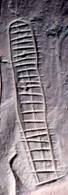
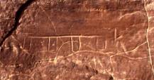
pictures 3 + 4: Two variants of water mountain ideograms
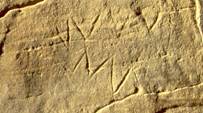
picture 5: water mountain ideogram into which the cartouche
of pharaoh Djedefre (4th dynasty) is insribed
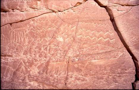
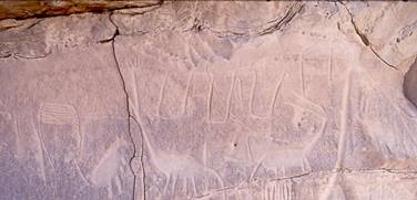
picture 6: Biar Jaqub watermountain ideograms and Neolithic fauna at water mountain outpost No. 10
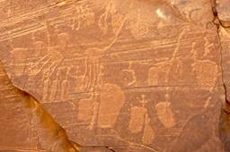
The rock art of the Giraffe Hunters (picture 7) which lies in close proximity to the two sites where the eggshells were discoverd, and which contains images of the mid-Holocene fauna as well as
a.) steatopygeous human figures (females)
b.) irrigated fields (and, possibly)
c.) pictograms of boats and crocodiles
d.) water mountain ideograms etc.
is, therefore, much older than previously assumed. (see earlier reports on this website) Henceforth, its age has to be fixed at about 1,000 years prior to Naqada II.
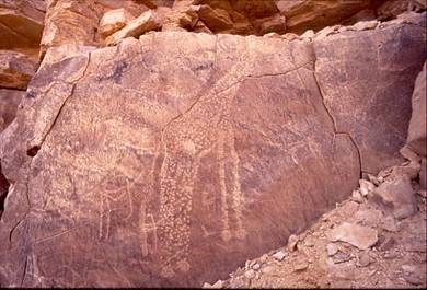
picture 7: self-portrait of the Giraffe Hunters of Biar Jaqub engaged in a hunt
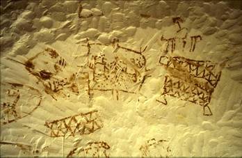
B. Earlier assumptions about the age of the Biar Jaqub proto-hieroglyphs disproved
Neglecting the fact that the arrangements of some of the water mountain symbols in Biar Jaqub are apparently interrelated with Neolithic petroglyphs of giraffes as well as of other animals and that some of these depicted fauna are superimposed onto the water mountain symbols (pictures 8 + 9), K.P. Kuhlmann (a German Egyptologist) has put forward the ill-founded proposition that the biliteral sign of the water mountain originates in the pharaonic period. (Kuhlmann, K. P.: Der „Wasserberg des Djedefre“ (Chufu 01/1) Ein Lagerplatz mit Expeditionsinschriften der 4. Dynastie im Raum der Oase Dachla. Mitteilungen des Deutschen Archäologischen Instituts Abteilung Kairo, Bd. 61 (2005) pp.271-275).
In the light of the radiocarbon datings presented in this paper Kuhlmann´s interpretation has lost its credibility. If (as I have stated on my website before) water mountain symbols and other ideograms are regarded as proto-hieroglyphs, that is, as characters of a rudimentary “writing system” which most probably, was used for the (religious and/or environmental) description of the world as well as for communication purposes, then the collection of signs, which I have managed to detect in Biar Jaqub, and which constitutes parts of the origins of the ancient Egyptian script, is approximately 1,000 years older than so far assumed.
picture 8: Neolithic fauna superimposed on water mountain symbols at water mountain outpost No. 9
picture 9: Giraffe partly superimposed on water mountain symbol
C. Description of the places of discovery & conclusions
Their place of discovery reveals that the decorated ostrich eggshells are intimately embedded into a context containing diverse artefacts from the Giraffe Hunters & Nomadic Cattle-Pastoralists camp (a stone circle settlement of considerable size). The proximity of all these various remains including the rock art engraved in a semicircle around the fringes of the camp, indicates that all these features are directly linked. This extremely rare setting of remains allows well-founded analogies between age & style of the decoration of the ostrich eggshells and the rockart very close by. No doubt, those who incised the ostrich eggs with cross-hatched & herringbone bands and triangles are also the ones who adorned the nearby rockfaces of their camp with images of giraffes, steatopygeous human figures and a water mountain symbol.
To the best of my knowledge, the discovery of these decorated ostrich eggshells allows access for the first time to dating of Western Desert (of Egypt) decorative art as well as to rock art including a cluster of proto-hieroglyphs created by Saharan Giraffe Hunters and Cattle Pastoralists long before the Pharaohs. (For a discussion of geometric art engraved on ostrich eggshells found at Capsian and Neolithic sites in Tunsia, Algeria and the Magreb see Belhouchet, L. Les gravures sur coquilles d´oeufs d´autruche en Afrique du Nord: interpretation des decors geometriques. SAHRA 19 (2008) pp. 77-84) On the basis of the above and with greater clarity than before, Biar Jaqub may now be revealed as one of the sites from where, starting from the beginning to the middle of the 5th millennium BC, the first tentative steps towards formation of a pool of written signs were taken, partly forming the basis of the much later Pharaonic script. Since the art on the egg shells (represented by three artistically well executed fragments) paves the way for identification of the ethnic group which created the decoration in question, the following may now be pointed out with more certainty.
D.) Mid-Holocene Cultural Units of the Dakhla region
1.) The reservoir age adjusted radiocarbon time spread (cal BC 5,157-4,673) presented above seems to refer to a period when the region of the Dakhla oasis was occupied by two cultural units known as the Bashendi unit (BU) (approximately dating to the “Middle Neolithic” 7,700-6,200 BP or even younger. See M.M.A. Mc.Donald: Neolithic cultural units and adaptions in the Dakhleh oasis in: C.S. Churcher, A.J. Mills (eds): Reports from the survey of the Dakhleh oasis. Western Desert of Egypt. 1977-1987. Oxford 1999, p. 122) and the Sheikh Muftah Unit (SU) (roughly dating from the middle of the 6th millennium BP to well past 5,000 BP. Ibidem p. 126) The BU “… might have survived beyond 5,500 BP …if the features it shares with the Sheikh Muftah and the Nile Valley Predynastic imply some contemporaneity with these latter units rather than, for instance, a simple ancestral relationship to them.” (ibidem) According to Warfe, the BU may be subdivided into the Bashendi A (dated 7,600-6,800 BP) and the Bashendi B (dated to 6,500-5,200 BP). “Besides being temporally separate, the units differ in subsistence strategies, patterns of adaption and in site location.” (A.R.Warfe: Interregional contacts with the Sudan: Ceramic evidence from the mid-Holocene period. In: G.E. Bowen; C.A. Hope (eds.) The oasis papers 3. Proceedings of the third international conference of the Dakhleh Oasis Project. Oxford 2004, p. 79) Thus, the radiocarbon dates presented above may be assigned to the Bashendi B cultural unit.
2.) It is generally accepted that the BU “… groups were not oasis dwellers, but rather the local version of the nomadic pastoralists whose campsites are scattered across the central and eastern Sahara.” (M.M.A. McDonald, op. cit. p. 127) Indeed, “… aspects of (their) material culture point to some degree of nomadism,… the scarcity of pottery, at a time when it had already been used in the area for thousands of years, conforms with the pattern for non-sedentary societies.” (ibidem) “Cattle (bones) were found at virtually all (their) sites…it seems likely that the Bashendi cattle were herded.” (ibidem, p. 120) Due to their nomadic lifestyle, the Bashendi, in all likelyhood, possessed intimate knowledge of the desert, and therefore most of the rock art depicting typical African savanna animal motifs (such as giraffe, elephant, hyppopotamus, zebra, buffalo, ostrich, gazelles and hartebeest) which has been discovered since the 1930s in the wider (desert) environs around Kharga and Dakhla oases, may tentatively be assigned to these BU groups. It is therefore not surprising that BU camps have occasionally been found in close proximity to such rock art sites. (see also“Wilkinson´s zweites Zerzura” on my website)
3.) On the basis of
a.) the geometrically designed decoration depicted on the ostrich eggshells described above (picture 2)
b.) the dating obtained for these (as well as the undecorated) items
c.) the locations of their discovery
it is now certain that BU group individuals were responsible for producing the rock art in question. Moreover, apart from other “ideograms”, they also invented the water mountain “symbols”, consequently creating a pool of signs which, in later times, became part of the pharaonic script. The self-portraits of these BU groups, consisting of steotopgyneous female figures and their slender male counterparts, are found at several sites in the desert. (pictures 10 + 11)
 .
. 
picture 10: steatopygeous female figures and their slender male counterparts
picture 11: steatopygeous figures amongst giraffes
E.) Spatial & temporal distribution of water mountain symbols and further implications
1.) I have discovered water mountain ideograms of much younger date in the vicinity of Farafra oasis. The symbols which, in my judgement, represent watering places (for cattle), are incorporated into a ceiling fresco belonging to the early Christian period. (picture 12) This proves that the water mountain ideogram developed at the beginning of the Predynastic period prevailed in the Western Desert oases until around 400 AD.
picture 12: image of a “water mountain” (on the right) being used
as a watering place for cattle (Farafra oasis, Early Christian period)
Kröpelin and Kuper observed such ideograms at Gala El Sheikh west of Dongola/Sudan. However, by adopting Kuhlmann´s wrong chronological projection without critical appraisal, the two authors arrive at vague and partly wrong conclusions. Quoting Kröpelin & Kuper directly: „... the isolated but identical presentation of the „water-ideograms“ more than 700 km south of the Dakhla area... bears implications for the question of early Egyptian relations with Sudanese Nubia. It suggests a line or a network of communication across the Eastern Sahara as late as the early third millenium BC. … The new evidence supports the scenario that even after 3,000 BC the Libyan Desert was not completely void of human activity. In its southern part, cattle keepers could survive as late as the secound millenium BC… Apparently, the Egyptian Nile valley and the oases were connected with these regions and farther African destinations beyond by a network of donkey caravan routes crossing southern Egypt. Even if Egyptian activities from the Egyptian side were probably limited to occasional ventures such as the expeditions during Cheops´ reign or Harkhuf´s journeys, the “First World” along the Nile must have been a constant lure to the people at its peripheries.” (Kröpelin, S.; Kuper, R.: More corridors to Africa. Cripel 26 (2006-2007), pp. 225, 226)
2.) The type of periphery envisaged by Kröpelin & Kuper may not have existed around 5,000–4,500 BC. In addition, a network of north or south bound corridors (as the headline of Kuper´s & Kröpelin´s article is suggesting), along which the traffic of the desert rolled on, in all likelihood, did not exist either. Because (as Kröpelin & Kuper remark on p. 219) until about 5,000 BC, the landscape which is now a desert, consisted mainly of savannah and steppe fed by the steadily declining rainfalls of the Mid-Holocene Wet Phase. Due to such precipitation BU groups most probably were able to roam across this huge terrain without limitations just as well as they were able to squat or to settle wherever they found wildlife or appropriate grazing for their cattle as was also their custom. Such a scenario would easily explain the presence of water mountain-ideograms at Gala El Sheikh as well as the ubiquitous occurrence of images of steatopygeous human figures further north. (Apart from that Kuper & Kröpelin would have to prove that their find at Gala El Sheikh does not coincide either with early Christian activities in the Dongola reach, of which the ruins of Gala El Sheikh might have served as an outpost, or with activities & movements during Napatan times, of which another fortress-like ruin named Gala Abu Ahmed bears witness in the lower Wadi Howar.)
3.) The BU “… is a product of nomadic pastoralists who may have ranged well beyond the limits of Dakhleh…” (M.M.A. McDonald, op. cit. p. 128) BU camps in that region such as the Biar Jaqub site 2007/08-37b may be envisaged as “… annual refuge or aggregation points for mobile cattle-herders… Such localities “… would have become increasingly attractive … as the wider region began to dry out by the VI Millennium BP.” (ibidem) The stone slab structures of site 2007/08-37b suggest a move towards sedentism, although the “..Bashendi B groups from Dakhleh, for instance, appear to have been predominantly mobile in nature.” (A.R. Warfe, op. cit. p.86) In addition to and as a consequence of the steadily declining precipitation, BU groups would have been constrained by deteriorating environmental conditions, to turn their attention to water holes and wells much more than previously. This environmentally controlled “cognitive adaptation process” ultimately found its expression in the creation of analogous representations (signs and ideograms), of which the water mountain sign is the most prominent one. (For a more detailed elaboration of this transformation process see “Wilkinson´s zweites Zerzura” on my website)
4.) The existence of site 2007/08-19 shows that Kröpelin´s & Kuper´s “corridor theory” is not applicable for the period during which water mountain ideograms were originally created. This locality which was most probably permanently occupied, can be found more than 100 kilometres distant from Biar Jaqub. It contains a limited but comparable stock of rock art (including a representation of a steatypogeous individual), petrified bone fragments, an abundance of stone tools as well as two fine-tempered and thin-walled potsherds of Beshendi B provenance detected in the “kitchen area” of the settlement. The site is contemporaneous with sites 2007/08-37b + 39c. Its existence therefore, supports the idea that until around 4,600 BC Giraffe Hunters and Nomadic Cattle Pastoralists were still spread out over the whole Sahara in order to herd their cattle. (Note that in the wider environs of site 2007/08-19 three additional BU-camps of considerable size have been observed during a brief survey.)
5.) The new dating of the activities & presence of Giraffe Hunters and Nomadic Cattle Pastoralists in the Dakhla region and elsewhere (spatially) augments earlier assessments put forth by C. S. Churcher. (see C. S. Churcher: Holocene faunas of the Dakhleh oasis. In: Reports from the survey of the Dakhleh oases 1977-1987. op. cit. pp.133-151) Picture 13 shows Curcher´s reconstruction of the landscape and megafauna of the Dakhla oasis in BU times (in which however, cattle are not present). During that period most probably, a similar landscape may be indicative of Biar Jaqub and, as found so far, of the wider surroundings of site 2007/08-19.
picture 13: Reconstruction of landscape and megafauna of Dakhla Oasis in Bashendi Cultural Unit times.
Cited from C.S. Churcher: Holocene faunas of the Dakhleh oasis. In Reports from the survey
of the Dakhleh oasis 1977-1987. op. cit. p. 146)
II. Results of age determinations related to Naqada II
Three datings related to Naqada II (spanning the period of cal BC 3,360-2,923) were obtained from Biar Jaqub and its surroundings. These were:
a.) Charcoal from a fireplace found in the kitchen area of a stone circle settlement in the vicinity of Yellow Hill (2007/08-24): BP 4.308 +/- 26 (Two Sigma Range: cal BC 3.092-2.923: probability 95,4%)
b.) Charcoal from a fireplace at KH-Krug (2007/08-27): BP 4.530 +/- 30 (Two Sigma Range: cal BC 3.360-3.103; probability 95,4%)
c.) Charcoal from a fireplace at Berbaum 2 (2007/08-46): BP 4.522 +/- 29 (Two Sigma Range: cal BC 3.356-3.102; probability 95,4%)
Whilst the first two values were derived at sites from Biar Jaqub proper, the third is from a depression about 12 kilometres northwest of the palaeoasis. This swale is sunk circa 25-30 metres deep into an area surrounded by limestone. Several low lying sandstone hills and rock outcrops rise from its bottom. Contact with beds of Nubian sandstone that formerly bore water may therefore be assumed. In close proximity to the sandstone elevations a sizable former lake (now a flat playa expanse exposing a few fishbone remains) occupies parts of the depression. On this playa, Berger et al found well preserved roots, trunks and branches of tamarix (picture 14). Two samples of the wood were dated to the Second Intermediate period (cal BC 1.604 – 1.525 and cal BC 1.729 – 1.621). Last winter I camped in this depression in order to explore the area and found four sites containing habitation remains. Compared to the stone circle settlements of the Giraffe Hunters & Pastoral Nomads at Biar Jaqub, these four sites which are contemporaneous with Naqada II sites, are noticeably smaller & inconspicuous. Whilst one site consists of a rock face and a cube-like rock adorned with faded, rudimentary rock art as well as a few potsherds at their basis, another, situated below an overhang (Berbaum 2), contains a fireplace, a considerable amount of potsherds, grinding equipment, remains of a Sheikh Muftah pot and a much eroded Clayton. (pictures 15-17)
picture 14: Remains of tamarix dated to the Secound Intemediate period
picture 15: Berbaum 2, overall view
picture 16: Sheikh Muftah cooking pot at “Berbaum 2” exhibiting traces of charcoal on its outer wall
picture 17: partly disintegrated Clayton from the same site
According to the prevailing theory, the invention of writing in Egypt would roughly have taken place in the beginning of the time period covered by the three datings presented above (cal BC 3.360-2.923). However, the sites from which the charcoal samples have been extracted are not situated in the neighbourhood of any distinguished Biar Jaqub rock art, nor in the vicinity of graffiti of the type which may be considered proto-hieroglyphic. Does the lack of such an association again point to the likelyhood that the first attempts to invent the Hieroglyphic script did not emerge during dynasty 0, but instead, that this event took place roughly a thousand years before, that is: sometime during the era of the Giraffe Hunters & Nomadic Cattle Pastoralists?
In any case, the three datings presented in this chapter indicate that climatic and environmental conditions during the Naqada II period were such that humans could occupy Biar Jaqub and its surroundings. (Consistent with this is the presence of a Sheikh Muftah pot at the fireplace of Berbaum 2, see pictures 15-17) Due to the limited scope of my initial survey, firm conclusions about the ancient population density and the type of occupation of the sites can not as yet be drawn. Also, for the time being, the question as to whether or not pictograms of boats and crocodiles and the like (picture 20; see also former reports on this website) originate from Naqada II, cannot as yet be settled. There are indications that such graffiti might be older. More time and effort are needed to decide this issue.
Side note: At water mountain outpost No 9 (a Biar Jaqub site which I discovered in February 2002) I observed a Sheikh Muftah cooking pot (picture 18) positioned on a narrow (approx. 25 centimetres wide) ledge situated at the top of a steep slope about 5 metres above the wadi floor. (picture 19) Immediately beneath the pot, sizable remains of fire places (two strata of charcoal) were detected. Nobody could built a fire and cooked a meal in such an uncomfortably steep and narrow spot. Such a setting hints to the complete erosion of horizontal beds of playa that formerly surrounded the sandstone hillock in question up to the level were the charcoal remains were found. The hillock is decorated (above the top soil) with water mountains, neolithic fauna, and irrigated fields as well as with two crocodiles attacking two men positioned next to a boat, hyenas and an enigmatic geometric emblem. (picture 20)
picture 18: Sheik Muftah cooking pot at water mountain outpost No. 9 picture 19: original in situ position of the pot
picture 20: Water mountain outpost No. 9 - two crocodiles attacking two men next to a boat.
To the left, enigmatic geometrical sign.
Last winter Kuper´s team extracted charcoal from the site. (In my opinion, this material will yield a Sheikh Muftah date.) One might argue that because the pot and the charcoal are from the Sheikh Muftah period, then the engravings at the site also belong to the Sheikh Muftah culture. However, the leisure time needed to scratch the rock art that can be seen in the adjacent sandstone rock faces of the site, would normally suggest a settlement of some kind. Does a single isolated pot and fire place constitute a settlement with inhabitants? In my opinion, more evidence of habitation (as in the case of the stone circle settlements of the Giraffe Hunter & Nomadic Cattle-Pastoralist; see chapter I.) is needed, to confirm such an idea. (Last winter Kuper´s team also dug out a single stone circle about 250 metres to the north of watermountain outpost No. 9. Hopefully, some datable material has been extracted from the site.)
Just one Biar Jaqub sample yielded a date which belongs to Middle Kindom times.
Tamarix wood & charcoal from a fireplace found in a stone slab semicircle (2007/08-34): BP 3.586 +/- 23 (Two Sigma Range: cal BC 2.020-1.885; probability 95,4%)
Despite contrary assertions, this dating reveals that human occupation at Biar Jaqub can satisfactorily be assumed for a period ranging from Mentuhotep II. (11th dynasty) to Sesostris II (12th dynasty). Concerning the presence of fauna during the Second Intermediate period and the beginning of the New Kingdom, see the dating of gazelle droppings (cal BC 1.680-1.462; report on winter 2006/07-expeditions, Latest news from Biar Jaqub).
In addition, three TL-datings may be assigned to the Middle Kingdom. One of them was obtained from a potsherd found in Biar Jaqub. The second dating was obtained from another potsherd found on the Abu Ballas Trail (TAB), and the third is from the Kufra Trail (KT). The context of the last finding indicates that the travelers of those times were mainly of modest means and that they were able to cross the Western Desert of Egypt from Dakhla Oasis to the Gilf Kebir (and, possibly, further on to Kufra) without the official support that was available on the TAB. The second date obtained from a piece of ceramic material found in the vicinity of the “Cone” (marked on the British map approx. 10 kilometres south of El-Aqab el Qadim) confirms that the pots in question were made during the First Intermediate and Middle Kingdom periods. This reveals that apart from the “main road” across the plateau of the Gilf Kebir, a side track had also existed which proceeded along the eastern fringes of the Gilf Kebir in the direction of Gebel Uweinat.
Side note: In 2001, Kuper (and his team) had strongly rejected my idea that the TAB might extend to Gebel Uweinat (this, in spite of the fact that the TAB´s alignement heads almost straight to it; see for instance R. Kuper´s unfounded proposal in: By donkey train to Kufra? - How Mr. Mery went west. Antiquity 75 (2001) pp. 801-802) and he had therefore further and wrongly insisted that the “cone” pottery, now proven to be of Pharaonic origin, must belong to the Neolithic period.
In several publications on this website I had dismissed Kupers mistaken assertations and argued in favour of Gebel Uweinat being an intermediate destination on the TAB, assuming that the latter would have extended further to the Ennedi and to the Lake Tschad Basin. (see for instance Results of winter 2003/04 - Expeditions and Results of Winter 2005/06 Expeditions, chapter E. Supplement: Note on Islamic relics on the TAB…) Eventually, in 2007 Förster (an Egyptologist belonging to Kuper´s team) accepted my conclusions (I had informed him personally about my writings.) and published my ideas on the subject in: Förster, F.: With donkeys, jars and water bags into the Libyan Desert: the Abu Ballas Trail in the late Old Kingdom/First Intermediate Period. p. 7, accessed at http://www.thebritishmuseum.ac.uk/research/publications/bmsaes/issue_7/foerster.aspx, but he made no mention of the fact that the idea`s he was putting foreward in his article, concerning the TAB and Gebel Uweinat, had already been proposed by myself several years before in various publications. He therefore gave the impression to readers that the idea that the TAB may extend to Uweinat and beyond is his own.
Consequently, in 2008, when the discovery of an inscription at Gebel Uweinat from the reign of Mentuhotep Nebhepetra (2,055-2004 BC) was announced in SAHARA magazine (Clayton, J.; De Trafford, A., Borda, M.: A hieroglyphic inscription found at Jebel Uweinat mentioning Yam and Tekhebet. Sahara 19 (2008) pp. 129-134) Foerster was acknowledged as the first person to have realized that the TAB may lead to Gebel Uweinat and beyond.
Submitting the work of another person under one´s own name is university based science (as Kuper & Kroepelin understand it) at its best. If junior students are guilty of dishonesty in academic work, they are subject to penalties. But it seems that if such plagiarism happens in the senior academic body of a university itsself (in this case as in many others, for the sole reason of systematically downsizing my discoveries and/or deleting my name from the record so that the wiseheimers´splendour may increase) there is no code of ethics whereby the cheater may be held accountable. Therefore, it is necessary for me to expose these unfair practises to the readers on this website.
For the purpose of evaluating movements on the ancient KT four new TL-datings obtained from pottery fragments are now available. A fifth one was derived from a newly discovered TAB station of considerable size, and a sixth from Biar Jaqub. Whilst the dating of the new TAB station sample reveals utilization of the trail prior to the 6th dynasty, the latter dating indicates that within a time bracket between 1,600 – 400 BC settlers were present in this “lost oasis”.
Owing to lack of time (moving house to East Germany and assisting my 80year old mother after surgery) I am not in a position to discuss the dating results presented in this paper at length. A detailed review will be presented in my final expedition report. This publication is scheduled for summer 2009.
The radiocarbon datings obtaind from my winter 2007/08 expedition reveal a decisive development in the settlement patterns of humans in Biar Jaqub. This development consist of four stages:
1.) Giraffe Hunters & Nomadic Cattle-Pastoralists “villages”
An abundance of stone circle settlements of considerable size densly clustered around field temple (but also found elsewhere in the palaeoasis; see earlier reports on this website), account for an unusually high population density in Biar Jaqub during the Giraffe Hunters & Nomadic Cattle Pastoralists phase. Two of the sites have been dated to the period of around cal. BC 5,157-4,673. (Most likely, the majority of the other sites belong to the roughly the same period.) This span of time coincides with the onset of an era during which “arid episodes associated with Atlantic cooling events were superimposed on a gradual weakening of the northern hemisphere monsoon system …(thereby causing) a general trend towards enhanced aridity throughout the northern hemisphere extra-tropics, punctuated by more abrupt changes.” (N.Brooks: Cultural responses to aridity in the Middle Holocene and increased social complexity. Quaternary International 151 (2006) p. 33) In this context, it is a widely held view that regions which “…were well vegetated became progressively more arid after the end of the 7th millenium BP, reaching a state similar to that existing today during the 5th millennium BP.” (ibidem, p. 30) It has been suggested that proto-historic societies such as that of the Giraffe Hunters of Biar Jaqub, may have responded to the gradual climatic and environmental desiccation of the Sahara through a combination of increased mobility and sedentism in favourable locations. (see F. Hole: Environmental instabilities and urban origins. Chiefdoms and early states in the Near East: The organizational dynamics of complexity. Monographs in World Archaeology 18. Prehistory Press 1994, p. 123) The small “villages”of the Biar Jaqub palaeoasis and its rock art may reflect the effects of such changes which for instance was manifested in:
a.) Hunting and gathering beginning to give way to cattle herding “… as cattle would have provided (their owners) with a more predictable source of nutrition in the form of milk, meat and blood than could be acquired from exploiting wild animals and plant species.” (N. Brooks, op. cit. p. 34) These two livelihood models would have coexisted for a long period of time.
b.) A gradual movement of human settlements from the desert towards environmental refuges (such as Biar Jaqub) where water remained available even during times of desiccation.
c.) Plant cultivation and animal husbandry (The spread of cattle keeping and -pastoralism appears to have been encouraged by climatic deterioration. See F. A. Hassan: Palaeoclimate, food and culturalchange in Africa: an overview. In: F. A. Hassan: Droughts, food and culture. New York 2002, pp. 11-26)
d.) The exploitation of hand-dug wells at some of the Biar Jaqub playa sites (as evidenced in water mountain symbols found throughout the palaeoasis) dug in order to cope with water table levels that fell seasonally.
e.) “Village” farming (irrigation agriculture as evidenced in irrigated field symbols at Biar Jaqub) and pastoralism, with the latter involving in transhumance (large scale seasonal or year around movements in order to exploit remnant water and pasture).
f.) The emergence of a “cattle cult” (apparent in rock engravings throughout the Sahara).
g.) An increase in social complexity.
h.) The creation of a distinct set of signs and symbols (a process which may have been driven by a set of religious precepts as well as by the cognitive awareness of “…societies which were directly depenedent on their immediate physical environment for their livelihoods and food security.” N. Brooks, op. cit. p.44 )
Seemingly, in Biar Jaqub “…these developements did not necessarily depend on the prior emergence of an organizing elite…” (N. Brooks, op. cit. p.44). For instance, explicit representations of violence and authority (see R. Matthews: The archaeology of Mesopotamia: Theories and approaches. London 2003) are absent in the palaeoasis´ rock art of that time. That giraffe hunting was still a worthwhile profession until around cal BC 4,600 is attested by picture 7.
The remarkable cluster of stone circle settlements about 100 km from Biar Jaqub also hints to the possible existence of quite a few habitable areas located
- outside the oases belt of the Western Desert (of Egypt) and
- beyond regions with elevation-induced rainfall capture
where sufficient, all year around supplies of surface water & grazing were available for big game as well as for the cattle pastoralists during the period in question.
2.) Naqada II dwellings
These habitations dated to cal BC 3,360-2,923, differ from the “villages” built by the Giraffe Hunters & Nomadic Cattle-Pastoralists, as they consist of significantly smaller sized stone slab settlements and of isolated (singular) stone circles which implies a decline in population density of the palaeoasis by that time. (Those of the Bashendi B cultural unit who had left Biar Jaqub in the preceding epoch, may not have perished but would have migrated to the South or to the Nile Valley taking their animals as well as their beliefs, signs and symbols with them. Their ideograms were a building block of the Pharaonic script.) In addition, a scratched out engraving depicting a field at water mountain outpost No. 9 may hint to an increase in aridity and a degredation of land-use conditions in Biar Jaqub. According to the pottery remains, those who dwelled in Biar Jaqub around cal BC 3,360-2,923 were definitely members of the Sheikh Muftah cultural unit. Remnants of animal bones at the Yellow Hill site also support the idea that giraffes were no longer hunted.
Nevertheless, despite of the southward retreat of the monsoonal rainfall zone, sufficient water must have been available for the remaining inhabitants, as “…environmental desiccation would have lagged (behind) climatic desiccation in… (Biar Jaqub) where water persisted at or near the surface as a result of local geological conditions.” (N. Brooks, op. cit. p. 32) The populace of the palaeoasis were most probably still engaged in transhumance and exploited the arid steppe vegetation for their cattle, sheep or goats. Surprisingly, this activity may have continued until very recent times as various rumours concerning sporadic late 19th century AD cattle drives commuting between the Gilf Kebir and Dakhla oasis have been recorded (see Count Almasy, G. Rohlfs and others).
3.) 4th dynasty camps
The discovery of Djedefre´s Water Mountain (DWM) revealed that 4th dyn. exepeditions consisting of up to 400 conscripts were sent to the area to collect mefat (pigments) for embellishment of the tombs and temples at Giza. At least two camps of the “mefat expeditions” were discovered, one at DWM and the other one (of much smaller size) in its vicinity. (see previous reports on this website) Being of rectangular shape, these camps differ much from BU and SU habitations. (I might have found several SU dwellings contemporaneous with the 4th dynasty pharaonic camps however, due to a lack of funds it is not possible for me at the moment, to prove their age & the provenance of their contents precisely. In any case, it would be most unusual, if a region which was capable of supporting an expedition of more than 400 hands would have been void of seasonal or permanent habitation.)
In earlier reports on this website I have pointed out that the presence of 4th dyn. expeditions in the area of DWM and its surroundings, indicates (apart from pictorial and geological evidence) that shallow wells existed there. (No water jars or sherds thereof were found at the sites.). These wells also explain why this mineral (mefat) was not collected from the good quality pigment beds lying much closer to Dakhla oasis. The fact that the followers of Cheops and Djedefre chose a spot further away from Dakhla to collect this material shows that the expeditions relied on the availability of water and grazing (for their donkeys) at DWM and Biar Jaqub. These sites were probably the only oasis like desert sites that existed in the wider environs west of Dakhla oasis.
In addition, a test dig at DWM revealed a great number of locusts remains. Does this find indicate that the conscript´s nutrition was very basic?
The mere existence of the expedition camps points to the fact that despite increasing aridity, rain-bearing convection systems may have reached DWM and Biar Jaqub during 4th dynasty times (At DWM Kuhlmann identified a 4th dyn. graffito commemorating a thunderstorm.), causing major wet spells which promoted rises in local groundwater levels. Therefore, it is not astonishing at all that the cartouche of pharaoh Djedefre was incised into a water mountain ideogram (picture 5). This image of a well would have represented life giving water of which the pharaoh claimed control.
4.) Middle Kingdom habitations
So far, only one such habitation has been identified with certainty. The locality is very basic in character. It contains remains of two jars(?). Whether or not the site was permanently occupied cannot be ascertained at the moment. However, if there is one, there might be more. Presumably, a thorough survey of the palaeoasis will bring further such dwellings to light.
The site may hint to a remnant population dwelling in Biar Jaqub at a time when, according to prevailing thought, full desert conditions and an irreversible collapse of regional vegetation systems (outside of the oases of the Western Desert) had long taken place. Despite this, the habitation is indicative of a climatic regime wherein rain bearing clouds were still capable of filling local ground water reservoirs, which are a prerequesite for the florishing of grazing grounds and for herding as well as for other forms of subsistence. It remains to be seen from further detailed studies why human livelihood activities did not disappear completely in this “relic oasis”, which has wrongly been assumed to have dried out by late Old Kingdom times.
Heading towards the Gilf Kebir, two ancient caravan routes can be traced crossing the outskirts of Biar Jaqub. There, in a muhattah (way station) on one of these trails, a single, well preserved water jar of First Intermediate period origin was found. The capacity of this container would not suffice for the needs of a caravan. This alone also strongly indicates that water was available in this hyper-arid landscape.
Another ancient road connects Biar Jaqub with Muhattah Jaqub (MJ), an important way station on the TAB. In an earlier report I argued that the jars at MJ were filled with water most probably supplied from Biar Jaqub (so called lateral water supply). The existence of habitations dating to the beginnings of the Middle Kingdom may indicate a populace that might have been ordered to perform this job: remnant members of the Sheikh Muftah people. According to McDonald, the SU who inhabited parts of Dakhla oasis, peristed until the end of the Old Kingdom. See M.M.A. McDonald, op. cit. p. 126).
5.) Indications of human presence during later periods
Although it has been postulated that hyper-arid conditions which caused the drying of springs and the disappearance of surface water, were established in the Eastern Sahara by around 3,000 BC, sufficient evidence of human presence up to about 400 BC (and even later) has been gathered in and around Biar Jaqub. The pottery from this period does not contain a single water jar indicating that the precious liquid must either have been available in the palaeoasis or had been carried along in girbas (water skins). As the localities where pottery has been detected are bare of stone slab structures (indicating a dwelling), it is very likely that the pots were used during occasional visits after local rain fall. It is also conceivable that such visitors had expected to return to the places where they had hidden their pots.
6.) Further challenges
The evidence presented in this paper calls for thorough field studies, which would “… examine linked socio-cultural and environmental trajectories at the local scale (of Biar Jaqub). This will require numerous studies of individual settlement sites in order to illuminate the nature of changes in livelihood strategies, social organization and ideological framework, supported by palaeoenvironmental proxy data from the vicinity of the settlements in question.” (N. Brooks, op. cit. p. 44)
Carlo Bergmann
Sehlis 9/17/2008
Amendment to „Origins of the Hieroglyphic Scipt“
- List of Biar Jaqub Proto-Hieroglyphs -
Responses from readers to the article presented above have necessitated the addition of a short list of proto-hieroglyphs found in Biar Jaqub and its surroundings as follows:
I.) Basic signs
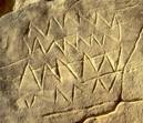
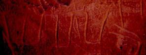
1.) Single orizontal zigzag line representing water (Over the lower right side of the zigzag line an ostrich has been superimposed.).
picture 21: “single water sign” at DWM
2.) (Horizontal) double zigzag line
picture 22: “double water sign” found at water mountain outpost No. 9
3.) Stack of horizontal zigzag lines presumably representing deep water.
picture 23: stack of horizontal zigzag lines from a site near Biar Jaqub
picture 24: stack of horizontal zigzag lines partly superimposed
by a steatopygeous figure (water mountain outpost No. 2)
4.) Effaced pair of horizontal zigzag lines
picture 25: effaced pair of water lines picture 26: close up under sidelight conditions
I studied this depiction several times during visits to water mountain outpost No. 9. There is a marginal chance that four of the vertical scratches belong to a quadruped. In this case, the meaning of the superimposition of an animal on water lines is not clear. However, if an attempt was made to deliberately efface the water lines then these signs must have possessed an important meaning of some kind. (A meaningless “character” would perhaps have been destroyed by accident but it would not have been destroyed deliberately.) Thus, the depiction may be interpreted as “no water available any more”.
5.) Two diverging zigzag lines possibly meaning “outpouring of water”.
picture 27: “outpouring of water” from a site in
the surroundings of Biar Jaqub
6.) Singular horizontal crenellated line (representing flowing water) amongst Neolithic fauna.
picture 28: A crenellated line at water mountain outpost No. 0 representing flowing water
picture 29: close up under different lighting conditions
7.) Irrigated field (always in vertical position)
picture 30: irrigated field (at DWM)
II.) Basic signs of uncertain provenance/meaning
1.)
picture 31
2.)

picture 32
III.) Sign combinations
These are signs that were “derived” by deliberately combining basic characters. Sign combinations found so far focus on the importance of water and its availability.
A.) Double zigzag line attached to an irrigated field indicating an unspecified water source feeding into a field.

picture 33: field irrigated by an unspecified water source
B.) Water mountain ideograms
1.) “Ideal” water mountain ideogram indicating a hand dug well.
Generally, water mountain ideograms consist of two mountain signs added to the upper right and left corners of a rectangular “vat” which contains a number of water lines. (picture 34)


picture 34: ideal type of a water mountain ideogram
picture 35: label from the Tomb U-j reading “mountains of darkness” (my drawing)
A label found by Dreyer in the Tomb U-j (circa 3.250 BC) at Abydos testifies to the use of mountain hieroglyphs in dynasty 0 times (picture 35). Davies and Friedman have interpreted the label´s inscription to mean “mountains of darkness” that is, “the Western Mountains” (or, my interpretation: the Western Desert. See Davies, V.; Friedman, R.: Egypt. London 2001, p. 37) The two signs in question are connected to each other, representing a silhouette of a mountain range as seen from a distance. In picture 34 the mountain signs are separated by a horizontal expanse. From the vantage point of someone spending a time in an area such as that between the hills of Biar Jaqub, the flat stretches of land would represent the layered (water-bearing) strata of playa in between chains of low hills. Presumably, wells were dug into this strata and the water mountain ideograms bear witness to the location of these wells.
On the occasion of Old Kindom visits to DWM, one can surmise that the two mountain signs belonging to the water mountain ideogram that bears Djedefre´s cartouche, were accentuated by additional strokes possibly indicating gullies descending from the elevations in question. (see picture 5)
2.) Variants of water mountain ideograms:
a.) water mountain ideogram indicating a water hole (picture 4)
b.) truncated water mountain ideogram indicating a shallow water hole (picture 36)

picture 36: truncated water mountain ideogram from water mountain outpost No. 9
c.) Water mountain ideogram containing an irrigated field and an outlet/inlet channel for water (on the lower right; picture 37)

picture 37: watermountain with spout
d.) Water mountain ideogram with horizontal compartments containing zigzag or wavy lines (picture 38)

picture 38: water mountain ideogram with horizontal compartments (from DWM)
e.) Water mountain ideogram with vertical compartments (picture 39)

picture 39: water mountain ideogram with vertical compartments (from DWM)
f.) Water mountain ideogram containing horizontal crenellated lines indicating a hollow in which water is flowing (picture 40)

picture 40: water mountain ideogram indicating flowing water (from water mountain outpost No. 9)
g.) Water mountain ideogram containing both zigzag and crenellated lines indicating seasonal water flow in a well (picture 41)

picture 41: water mountain ideogram containing zigzag and crenellated lines (from DWM)
h.) Ideograms representing water mountains, irrigation canals and irrigated fields amogst sparse Neolithic fauna. (picture 42) This “collage” which may represent the world´s oldest map or land register (The two pharaonic names found at this site are from a later period but related to the overall plan.) indicates the existence of “village” farming already during Bashendi Unit times.

picture 42: the world´s oldest land register (found at DWM)
IV. Preliminary conclusions
The discovery of proto-hieroglyphs in Biar Jaqub which have been dated to the beginnings of the Predynastic period, prove that ancient Egyptian “…writing developed from a more pictographic stage…” (Davies, V.; Friedman, R.: op. cit., p.36) roughly around 5,100 – 4,600 cal BC. Thus, these finds are likely to question the “…generally accepted theory that the invention of writing “…corresponds with the birth of the Egyptian state, and its growing administrative and bureaucratic needs.” (ibidem)
If, as has been suspected in the past some “…of the earliest uses of … writing (in Egypt) were to record the receipt of tax, and donate the origins of commodities and their production date…” (ibidem) it may now be ascertained that the need to create a (limited) set of signs (mainly focussing on water and its supply) existed long before the pharaohs. The early signs helped the Giraffe Hunters and Cattle Pastoralists of Biar Jaqub to deal with challenges provoked by their steadily deteriorating environment. Thus, the primal origins of the Pharaonic script may have not been initiated by bureaucratic needs but have to be regarded as a human response to climatic change.
V. Summary & Epilogue
Contrary to the prevailing opinion in Egyptology, it was not bureaucratic needs which facilitated the invention of a written language but rather, necessity per se (that is, the vital necessities of life itsself). This event was triggered off in the Western Desert of Egypt by gradual degradation of environmental conditions which slowly began to take effect at the beginning of the Predynastic period, circa 5.000 BC.
Thus, the precursor writing of the Pharaonic script which had resulted as a consequence of an adaptation process to climatic change, had already come into existence in the Western Desert of Egypt more than 1000 years before tribes, societies or other bodies of people, had developed their bureaucratic procedures & structures.
With the findings presented in this paper I have arrived at the summit of what is possible for a wanderer roaming the desert together with his camels. What will have to follow now is the elaboration of the details.
Sehlis and Berlin 9/28/2008
Carlo Bergmann
(of 9/30/2008)
To complement the information given in this paper two desert explorers, Alessandro Menardi Noguera (of Italy) and Mark Borda (of Malta) have kindly submitted photographs which testify to the utilization of zigzag lines being used to denominate water in predynastic times. The signs were employed by a little studied population of nomadic cattle herders who occupied the south-western part of Egypt´s Western Desert including Gebel Uweinat in prehistoric times.
1.) Alessandro Menardi Noguera´s discovery

picture 1: D-Stretch processed version of a rock painting exposing human figures
and a specimen of a water bag(?) found at Bu Helga Site, West Uweinat
by Alessandro Meinardi Noguera (by courtesy of the discoverer)

picture 2: Image of a rock painting (unprocessed) exposing human figures
and a specimen of a water bag(?) found at Bu Helga Site, West Uweinat
by Alessandro Meinardi Noguera (by courtesy of the discoverer)
Alessandro Meinardi Noguera writes: “…the Neolithic water mountain symbol is vaguely reminiscent of the bags represented in the Uweinat paintings.. Could (therefore) all your water mountain symbols be Neolithic representations of bags?”
In a few cases this may well be so. In fact, I have thought of this possibility myself but dismissed it as a general explanation. As I have to leave for Egypt in a couple of days, Alessandro´s proposal will be discussed in detail in the final expedition report due for publication next year.
2.) Mark Borda´s discovery
Alessandro´s case seems to be supported to some degree by an observation made by Mark Borda. In a cave situated between Gebel Uweinat and the Gilf Kebir , he discovered “…a homestead scene, where a man is portrayed kneeling down just outside the shelter. His left arm extends into the shelter and is holding, or is reaching to, what appears to be a type of bag. The bag is rounded in shape but on each of the top sides i.e., left and right, there is an upward pointing tapering projection and the proportions of the bag with it´s projections is the same as (the) water mountain “vat” ideograms with the mountains on either side.”(cited from Mark Borda´s mail) (picture 3).

picture 3: rock art discovered by Mark Borda in a cave situated between Gebel Uweinat
and the Gilf Kebir; photo courtesy of Mahmoud Marai)
picture 4: Close up showing the bag in question with water line painted in the centre.
A close up of the water bag (picture 4) reveals that “… exactly in the middle of the bag there is a perfect set of four zigzag lines in form of a “W”. Could this be a water sign of the type that represents water in your ideograms and in hieroglyphic writing?” (ibidem)
There can be no doubt that at least the latter observation & interpretation is correct. Thus the Neolithic population of the Western Desert used horizontal zigzag lines to denominate objects in which water was stored (here: a girba, that is, a water skin), or locations at which water was available.
Carlo Bergmann
Sehlis 9/30/2008
(of 10/17/2008)
The list of Biar Jaqub proto-hieroglyphs presented above contains a singular horizontal crenellated line which has been interpreted as a sign indicating flowing water. (see first amendment No. I.6)
Discussion
In 2005, K.P. Kuhlmann already reasoned that crenellated lines are representing water or rills and runlets. Referring to the Pyramid Texts, “…a collection of funerary rituals and spells first inscribed on the sarcophagi and subterranean walls of nine Old Kingdom Pyramids” (J.P. Allen, Pyramid texts, in D. B. Redford (ed.): The Oxford encyclopedia of ancient Egypt. Cairo 2001, vol. 3, p. 95) he pointed out that during late Old Kingdom times, a crenellated line signified the state of transhumance of nomads ranging the desert steppes as well as describing the meandering course of a sailing boat beating the sea. Beginning with the Middle Kingdom, the sign represented a winding village lane or street. (K.P. Kuhlmann, op. cit. P. 271)
Regarding crenellated lines Kröpelin and Kuper contribute the following blurry comment without offering a single proof to support their scepticism: “Leaving aside the open question if the emblems (water mountains) served a practical or an ideological function, there are arguments critical of Kuhlmann´s hypothesis, especially concerning the crenellated lines and how these can be linked to water.” (S. Kröpelin; R. Kuper: op.cit., p. 225)
That water actually was flowing in what is now the desert, and that crenellated lines were used as a sign to indicate a creak or a stream long before the pharaohs is substantiated by pictures 1 – 5. I found this singular, very special cluster of petroglyphs which may tentatively be dated to the Giraffe period, in a rocky wadi partly filled with sand and gently sloping towards a former lake in about ½ kilometre distance. Into the sandstone ground of the wadi´s eastern margin just below a vertical cliffside, three fish are incised. (picture 2) About one metre above them, the rock face is embellished with a conspicuous horizontal crenellated line. (picture 1) As there is no further rock art to be found in the immediate surroundings, there can be no doubt that the four petroglyphs were meant to belong together.


pictures 1 + 2: horizontal crenellated line found in close association with three fish at the eastern margin
of a rocky wadi


pictures 3 + 4: close up of two of the fish

picture 5: close up of an effaced(?) fish (to the right in picture 2)
In other words: At the time of the creation of the rock art in question the wadi was (at least seasonally) filled with flowing water, the latter being the habitat of fish of a presently unknown species.
Carlo Bergmann
Sehlis 10/17/2008
Fourth Amendment
(of 11/2/2008)
What is script (writing system)?
What is text?
Strengthening the case in favour of Biar Jaqub proto-hieroglyphs being the earliest roots of Pharaonic writing.
(German version)
Was ist Schrift?
Was ist Text?
Die Proto-Hieroglyphen, die ich am Wasserberg des Djedefre´ (DWM) und in Biar Jaqub entdeckte, haben durch K. P. Kuhlmann eine von meiner Einschätzung stark abweichende Beurteilung erfahren. Während ich belegen konnte, dass es sich um erste Ausprägungen der Schrift handelt, die der Periode um 5.100 – 4.600 v. Chr. entstammen, stufte sie Kuhlmann dem bloßen Anschein nach als Hinterlassenschaften der Expeditionsmannschaften aus der 4. Dynastie ein. (vgl. Kuhlmann, K.P.: op. cit., S. 271-282) Schrifthistorisch betrachtet ist dies ein gewaltiger Unterschied.
Wenn es stimmt, dass etwa um 2.800 v. Chr. die altägyptische Schrift in einem entscheidenden Schritt weiterentwickelt, und „...nunmehr auch Verbalformen und andere grammatikalische Elemente notiert wurden“ (Morenz, D.: Wie die Schrift zu Text wurde. Ein komplexer medialer, mentalitäts- und sozialgeschichtlicher Prozeß. In: Morenz, L.; Schorch, S. (Hrsg.). Was ist ein Text? Alttestamentliche, ägyptologische und altorientalistische Perspektiven. Berlin 2007, S. 29), dann war das Hieroglyphenschriftsystem nach einer Abfolge „...komplexer, weit über die Änderung des Zeicheninventars und der –formen hinausgehender Schriftreformen“ (ibidem, S. 31) lange vor der Herrschaft des Cheops voll entwickelt. Beleg hierfür ist u.a. der erste erhaltene, schriftlich formulierte komplexe narrative Text der Menschheit, der vom Schrein des Djoser (erster Pharao der 3. Dyn., ca. 2.740-2.720 v. Chr.) aus Heliopolis stammt. (ibidem, S. 30)
Wie nun allein schon der an DWM mögliche, direkte Vergleich zwischen den Expeditionsinschriften des Pepi, des Ijj-Meri (4. Dyn.) und anderer Personen auf der einen, sowie den in unmittelbarer Nachbarschaft eingravierten Proto-Hieroglyphen auf der anderen Seite nahe legt, entsprechen letztere diesem hohen Entwicklungsstand nicht. Solche „Niveauunterschiede“ mit möglicherweise mangelhaften Schreibkenntnissen derjenigen zu erklären, die ihre Vermerke und Zeichen an den Felswänden angebracht haben, würde nicht nur der Befundlage an DWM widersprechen, sondern auch sonst zu kurz greifen. Zudem lassen die Entdeckungen von Kröpelin & Kuper sowie von Alessandro Menardi Noguera und Mark Borda (siehe oben) vermuten, dass Wasser- und Zinnenlinien-Petroglyphen sowie Wasserberg-„Ideogramme“ nicht nur in Biar Jaqub sondern über einen Großteil der Libyschen Wüste verbreitet waren. Im Fall der im Nord-Sudan gefundenen Petroglyphen ist zwar bis dato die Zeitstellung nicht geklärt. Doch zumindest bezüglich der beiden anderen Felsbildfunde ist ein hohes Alter wahrscheinlich. Man darf gespannt darauf sein, inwieweit dieses mit den in Biar Jaqub ermittelten Werten korrelieren wird.
Im Lichte dieser jüngsten Entdeckungen, aber auch vor dem Hintergrund der oben angesprochenen gravierenden Datierungs- und Auslegungsunterschiede, erscheint es angebracht, in gebotener Kürze (aus Zeitmangel bin ich derzeit nicht in der Lage, einen längeren Text zu verfassen) weiter auszuholen und zu fragen, was „Schrift“ und was „Text“ überhaupt sind. Ausgangspunkt soll dabei der Kommunikationsprozess in oralen Gesellschaften sein.
„In den oralen Gesellschaften“... (stellte sich die Aufgabe), das sprachliche Handeln über die unmittelbare Sprechsituation im Hier und Jetzt hinaus weiterzugeben... lange bevor es zu irgendeiner Art von Schrift kam.“ (Ehrlich, K.: Textualität und Schriftlichkeit. In: Morenz, L.; Schorch, S. (Hrsg.), op. cit., S.10) Die „...Bearbeitung dieser Aufgabe... (erfolgte so), ...dass die Sprechsituation als der elementare Ort des sprachlichen Handelns zerdehnt..“ (und damit das) Interagieren ... von Angesicht zu Angesicht...“ (ibidem) aufgehoben wird. Dieser Vorgang wird u.a. im Institut des Boten besonders deutlich. „Er nimmt in seiner Person die sprachliche Handlung gedächtnismäßig auf, obwohl er nicht deren eigentlicher Adressat ist. In seiner Person transportiert er das, was der erste Sprecher sagte, an einen anderen Ort und damit auch in eine andere Zeit. Dort repetiert er das, was der erste Sprecher sagte, für den eigentlichen, nunmehr aber sekundären Hörer. In dieser Überbrückung der zerdehnten Sprechsituation findet sich eine Kernstruktur für die Bearbeitung der Aufgabe, die Flüchtigkeit des sprachlichen Handelns zu überwinden.“ (ibidem) Dazu treten andere „...Strukturen, die die Personen, die die Orte und die Zeiten betreffen,...hinzu.“ (ibidem, S. 10 f.) Alle diese Phänomene werden mit dem Konzept der Überlieferung zusammengefasst, wobei Texte das „...sprachliche Verfahren der Überlieferung..“ sind. (ibidem, S. 11)
Es darf angenommen werden, dass die in der zweiten Hälfte des 5. Jahrtausends v.Chr. lebenden Giraffenjäger und Rinderhirten von Biar Jaqub weitgehend diesen und den nachfolgenden Vorstellungen bezüglich des sprachlichen Handelns in oralen Gesellschaften entsprachen.
„Die systematische Herausbildung des Textes und damit das, was diesen kennzeichnet, die Textualität, hat zum Teil erhebliche Auswirkungen auf die sprachlichen Strukturen, die dabei eingesetzt werden. Sie erleiden eine Reihe von charakteristischen Transformationen...“ (ibidem) Demnach ist „...vom Symbolfeld der Sprache ein eigenes und eigens zu charakterisierendes Zeigfeld... (zu unterscheiden), das von der Vertextung massiv betroffen wird... Ausdrücke wie „hier“, „jetzt“, „ich“ usw. .. dienen dazu, innerhalb der Interaktion zwischen Sprecher und Hörer eine Synchronisierung der Aufmerksamkeitsleistung zu erzielen, und zwar in dieser Sprechsituation selbst und bezogen auf das sinnlich Wahrnehmbare... Die (spätere) Verdinglichung des Textes durch die Schrift hat eine Reihe von weiteren Affektionen des sprachlichen Handelns und der sprachlichen Subsysteme zur Folge. Diese Verdinglichung betrifft zunächst die Materialität des Trägermediums... Stein ist etwas anderes als Papyrus... Ganze Epochen der menschlichen Traditionsgeschichte werden durch diese Materialität charakterisiert.“ (ibidem, S. 13 f.)
„Der verdinglichte schriftliche Text hat gegenüber der immer etwas misslichen Einbindung in die Unmittelbarkeit der Sprechsituation... für die Wissenschaft eine ganz besondere Attraktivität. Hier finden Wissenschaftler Objekte ihrer Beschäftigung vor... (denen man als) sinnlich zugängliche Objekte habhaft zu werden“ (ibidem, S. 15) versucht. Dabei ist es üblich, schriftliche Texte als „... von allen Interaktanten losgelöste Objekte... (wahrzunehmen und zu bearbeiten), herausgelöst aus den – zerdehnten – Sprechsituationen, denen sie sich verdanken, isoliert gegen die Überlieferungsprozesse, deren Medium sie sind.“ (ibidem) Damit einher geht eine häufig „..jeder Reflexion entzogene Verdinglichung des Objektes „Text“... (und) die hartnäckige Weigerung, sich von den schriftlich zubereiteten Texten nicht einfach auch die Analysekategorien selbst vorgeben zu lassen... Es zeigt sich also, dass das Verhältnis von Textualität und Schriftlichkeit bis in die Bedingungen seiner reflektorisch-analytischen Bestimmungen hinein uns mit einem schwer aufzubrechenden kategorialen Zirkel konfrontiert.“ (ibidem, S. 15 f.) Dieser Zirkel mag Ursache dafür sein, dass Kuhlmann die Überlagerung von Wasserberg-„Ideogrammen“ durch Repräsentanten der neolithischen Fauna als zeitliches Bestimmungskriterium nicht in voller Strenge gelten ließ und damit den DWM-Proto-Hieroglyphen in eklatanter Fehleinschätzung ein in die 4. Dynastie weisendes Alter zusprach.
„Erst dann, wenn eine Analysebasis gefunden ist, die diesem Zirkel nicht verpflichtet bleibt, zeichnen sich Möglichkeiten für eine andere Art von Textlinguistik ab, die geeignet ist, neue Perspektiven... zu eröffnen.“ (ibidem, S. 16) Ein Ansatzpunkt dafür ist die Überlegung, wonach die „.. Herausbildung der sowohl bildliche als auch phonetische Elemente in sich vereinigenden Kulturtechnik „Schreiben“ mit ihrer engen Bindung an die Sprache (die visuelle Kommunikation) rationalisierte und (zu einer) .. folgenreichen graphischen Vereindeutungsmöglichkeit“ (führte). (Morenz, D.: op.cit. S. 20) Dabei wurde das komplexe System Sprache nicht „... völlig verdinglicht, sondern nur der Kern davon, der erst bei der Lektüre wieder gleichsam mit Geist behaucht wurde. Tatsächlich bestehen grundsätzlich durchaus recht offene Grenzen zwischen Mündlichkeit und Schriftlichkeit... In Form der Schrift wurde ein Teil des medialen Systems einerseits abgeschlossener, zugleich aber auf einer höheren Ebene komplexer und damit wiederum offener, d.h. interpretationsbedürftiger und –fähiger.“ (ibidem, S. 20 f.)
Nach meinem Dafürhalten sind die an DWM und in Biar Jaqub in den Sandstein geritzten „vorgeschichtlichen“ Botschaften erste Vorläufer dieser Entwicklung. Kommt ihnen aber bereits Schriftcharakter zu?
A. Gardiner charakterisiert das Typische der Pharaonenschrift, indem er bemerkt: „The hieroglyphic writing is an offshoot of pictorial art, a very early and important function was to provide a visible record of facts and occurrences, accessible to those who… were beyond the range of the spoken word… (When) the Egyptian discovered the principle of rebus or charade… the limitations of pictorial art as a medium for conveying or storing information (were overridden)... The new departure consisted in using the pictures of things, not to denote those things themselves or any cognate notions, but to indicate certain other entirely different things not easily susceptible of pictorial representation, the names of which chanced to have a similar sound. Obviously proper names could only be communicated in this way, and it is perhaps with them that hieroglyphic writing began.” (Gardiner, A.: Egyptian Grammar. Third edition. Oxford 1979, S. 6 f.)
Was in Biar Jaqub zunächst auffällt, ist die Tatsache, dass die vorgeschichtlichen Schriftsymbole ganz praktischen Zwecken der Benennung, des Zeigens (Hier ist ein Brunnen! usw.) oder womöglich gar schon deskriptiven Intentionen dienten, sie demzufolge noch nicht zu einem „...geheimnisvollen Informationssystem und Wissensspeicher für „Initiierte..., das eine geradezu magische Aura aufwies...“ (Morenz, D.: op. cit., S. 21), gereift waren. Sie ähneln darin den Zeichen der bisher auf die Entstehungszeit um 3.150 v. Chr. datierten Früh-Schrift. „In der noch relativ wenig abgeschlossenen Früh-Schrift wurden fast nur Onoma (Benennungen) phonetisch notiert, und die Fixierung syntaktischer Verknüpfungen blieb jedenfalls ausgesprochen selten. Eine der umfangreichsten syntaktischen Kombinationen dieser Zeit bietet eine Rebus-Schreibung aus den drei Elementen bnr, sr und nhh, die als ... „der Herrscher ist angenehm, ewiglich“... interpretiert werden kann.“ (ibidem) Kuhlmann hat das Wasserberg-Ideogramm spontan als „dw mw“ bzw. „dw mw nmj“ (Berg des fließenden Wassers) gelesen. (Kuhlmann, K.P. op. cit. S. 258, 271) Ob man es wagen darf, diese Kombinationen als Rebus-Schreibungen zu betrachten, vermag ich nicht zu entscheiden. Allerdings spricht bei gehäuftem Auftreten von Wasserberg-„Ideogrammen“ wie etwa an DWM einiges dafür; ebenso beim Wasserberg der Abbildung 37 „water mountain with spout“, der das Resultat einer Vier-Zeichen-Kombination ist. Derartige Kombinationen wirken bereits wort- bzw. „satzartig“.
Insofern wären „Berg“, „Wasserlinie“, „Zinnenlinie“, „gespreizte Wasserlinien“ usw. nicht nur als graphische Repräsentanten konkreter Objekte bzw. Aktionen aufzufassen, sondern womöglich bereits als phonetische Elemente einer in erster Ausbildung begriffenen Schriftsprache zu werten. Auf jeden Fall darf man in Kombinationen derartiger Elemente frühe Versuche syntaktischer Verknüpfung sehen.
Daß dem so ist, belegt die Beobachtung, der zufolge offenbar Mitglieder der Mefat-Expedition aus der Zeit des Djedefre sich an dem aus der Tiefe der Vorgeschichte zu ihnen herüber gekommenen Semogramm des Wasserbergs „vergriffen“ haben, indem sie dieses, weil sie den Namen ihres Herrschers darin unterbringen wollten, abschliffen, die Wasserlinien tilgten und das „Ideogramm“ damit auf die Stufe eines Piktogramms zurückversetzten. Hatten sie das „von Beginn an“ in seinen Ursprüngen Angelegte, nämlich u.a. die beiden Berghieroglyphen, erkannt und das Wahrgenommene durch Hinzufügung von V-förmigen Ritzungen, „...die vielleicht Klüftungen oder Stratifizierungen im Fels wiedergeben sollen,“ bekräftigt?“ (Kuhlmann, K. P.: op. cit. S. 257) Ein schöner Beleg, der die fließende Grenze zwischen Bild und Wort aufzeigt, geliefert von den Gefolgsleuten des Djedefre selbst!
In diesem Zusammenhang weist Kuhlmann noch auf folgendes hin: „Schon in prädynastischer Zeit darf man davon ausgehen, dass Zeichenkombinationen mit dem dw-Berg gelesen wurden, so dass die Verbindung von Berg und Wasserlinien schon früh mehr als nur piktographischen Charakter besessen haben könnte, und eine Lesung derartiger Zeichen als dw mw „Wasserberg“ nahe liegt.“ (ibidem, S. 258) Was der Ägyptologe in Unkenntnis des tatsächlichen Alters der Wasserberghieroglyphen für die prädynastische Zeit annimmt, mag daher durchaus auch für das Neolithikum gelten. So betrachtet gehörten Wasserberge und nicht Siegelinschriften sowie die im Herrschergrab des U-J von Abydos aus der Zeit um 3.150 v. Chr. ausgegrabenen Etiketten zu den ältesten Belegen für phonetische Notation. Auf letzteren „...stehen vor allem Namen. Die einzelnen Etiketten weisen jeweils nur ganz wenige Zeichen auf, etwa einen Ortsnamen oder die Kombination von Herrschertitel + Herrschername... Die bloße schriftliche Bezeichnung,... aber auch die Gesamtaussage dieser Inschriften sind also hinsichtlich Länge und Komplexität noch ziemlich weit von textlicher Autonomie entfernt, werden erst im Rahmen einer Kontextualisierung deutbar. Der Leser muß also ... (einige) Daten... an das konsonantische Gerippe herantragen, um dieses graphische Skelett zu einem vollen Text zu entwickeln.“ (Morenz, L.: op.cit., S. 23 f.) Gleiches gilt für Gefäß-Aufschriften. „Auch sie werden erst im materiellen und situativen Kontext lesbar, sind selbst nur Wörter, aber eben noch nicht Texte im engerem Sinn. (Auch diese) Art der Notation... ist also extrem kontextabhängig. Dementsprechend bedarf die Lektüre eines weitgehenden Vor-Wissens des Rezipienten, um den Text aus dem konsonantischen Skelett der Schriftzeichen zu erwecken.“ (ibidem, S. 24) Nichts anderes ist bei den verschiedenen Ausprägungen der Wasserberghieroglyphen der Fall. Im Grundbuchauszug der Abbildung 42 erscheint die „Litanei“ des konsonantischen Gerippes komplexer; sie bietet Variationen eines vollständigen Satzes (etwa: „Das Feld X wird mit Hilfe des Brunnens Y bewässert.). Obwohl in den Horizont der Bildlichkeit gestellt, liegt auch bei dieser komplexen „Komposition“ m. E. eine konzeptionelle Schriftlichkeit vor.
Dass die in Biar Jaqub verwendeten Grapheme sich auf ein brennendes Thema, nämlich auf Wasser, dessen Qualitäten, dessen Vorkommen und dessen Beschaffung beschränken, und die Schrift in diesem Frühstadium nicht auch andere Lebensbereiche erfasste, ist nicht weiter verwunderlich. Denn nicht für das Alltägliche, sondern zu aller erst für das dringendste Bedürfnis formt sich ein Laut, ein Ausdruck und später die Sprache. Und in der Folge die Schrift? Alles übrige blieb weiterhin dem oralen Bereich vorbehalten, wurde also durch die Sprache betreut, wovon manches (z.B. Tierbeobachtung und Jagd) sich dennoch auf Felswänden in Form von Bildkunst niederschlug. Für eine breite Verdinglichung der Sprache brauchte es daher weitere Jahrhunderte, bis sich der Zeichenvorrat erweiterte und kompliziertere Regeln zu seiner Beherrschung erfunden werden mussten. „Erst in der entwickelten Schrift wurden auch verbale Formen und grammatikalische Elemente... systematisch phonetisch kodiert, der Text stärker - wenn auch keineswegs vollständig – verdinglicht und damit das mediale System Schrift stärker abgeschlossen.“ (Morenz, L.: op. cit., S. 22)
Carlo Bergmann
Sehlis, den 2.11.2008
Fifth Amendment
(of 11/19/2008)
What is script (writing system)?
What is text (writing)?
Strengthening the case for the Biar Jaqub proto-hieroglyphs
being the earliest roots of Pharaonic writing.
This text is based on excerpts from Morenz, D.: Wie die Schrift zu Text wurde. Ein komplexer medialer, mentalitäts- und sozialgeschichtlicher Prozeß. In Morenz, L.; Schorch, S. (eds). Was ist ein Text? Alttestamentliche, ägyptologische und altorientalistische Perspektiven. Berlin 2007, pp. 18 – 48, on Ehrlich, K.: Textualität und Schriftlichkeit. In: Morenz, L.; Schorch, S. (eds) op. cit., pp. 3 – 17, and on Kuhlmann, K. P.: Der „Wasserberg des Djedefre“ (Chufu 01/1). Ein Lagerplatz mit Expeditionsinschriften der 4. Dynastie im Raum der Oase Dakhla. MDAIK 2005, pp. 243-289. Quotes are freely translated and not featured. For details see fourth amendment (German version).
Whereas K. P. Kuhlmann assigned some of the rude characters inscribed on the rock faces at Djedefre´s Water Mountain (DWM) to 4th dynasty times, and interpreted them as the work of members of the Cheops and Djedefre mefat expeditions, I found out that these “inscriptions” originate from the Neolithic period (between 5.100 – 4.600 BC) thus, as far as I am aware, they are the earliest known distinct example of ideas being expressed in written characters. From the viewpoint of the history of writing this much earlier date for the origins of script is very notable.
At around 2.800 BC, the formation of the pharaonic script had experienced a decisive leap in its development as witnessed by the verbal forms and other basic grammatical elements that appear in hieroglyphs. Therefore, due to a sequence of reforms which, in complexity, by far exceeded mere variations of the established signs and characters as well as changes of their forms, hieroglyphic writing was developed well before the reign of Cheops. This fact is attested to by mankind’s first known written complex narrative text from the shrine of Djoser at Heliopolis.
If one compares the inscriptions of Pepi, Ij-Meri and other 4th dyn. mefat expedition members with the proto-hieroglyphs engraved in the close neighbourhood, one will notice at once that the latter are not consistent with writing that has arrived at an advanced stage of development. To explain such deficiency by assuming poor command of writing by those Egyptians who supposedly left these inscriptions would however, not comply with the evidence found in Biar Jaqub. At the water mountain outposts in Biar Jaqub, the same type of proto-hieroglyphs as seen at DWM are associated with Neolithic rock art only. In addition, the discoveries of Kröpelin and Kuper as well as those of Noguera and Borda (see above) lead one to suspect that zigzag- and crennellated lines (engraved into or painted on rock faces) as well as water mountain “ideograms” are not only distributed within Biar Jaqub and its environs, but are also spread across a sizable part of the Libyan Desert. With regard to the petroglyphs found in Northern Sudan it is not yet clear to which period they belong. However, regarding the latter two finds of rock art, a fairly old age seems most probable. It will be exciting to learn, to what extent their age correlates with the epoch to which the Biar Jaqub proto-hieroglyphs have been assigned.
In the light of the latest discoveries as well as in consideration of the enormous differences in dating and interpretation ascribed to my DWM and Biar Jaqub finds by Kuhlmann and myself (as addressed above), it seems appropriate to briefly explore the subject further by asking: “What, in fact is script?” and “What is text?” (Because of lengthy rehab treatment after cancer surgery I don’t have time to write an elaborate paper on this issue at the moment.) A short look at the communication methods of early oral societies will be a good starting point for this exercise.
In oral societies the job of transmitting oral information beyond the limits of face to face conversation, a problem which had prevailed long before the invention of writing, was settled by “straining”, respectively by “extending” (German: zerdehnen) the “conversational situation” (German: Sprechsituation) thereby, breaking away from direct face to face dialogue. This procedure is particularly evident in the device of the messenger. Although he is not the true recipient, the messenger memorizes oral information (intended to be a message) and delivers the spoken words of the original speaker to another person at a different place and time. Upon his arrival the messenger repeats the message to the designated recipient. This bridging of a “strained situation” of oral intercourse (German: Überbrückung der zerdehnten Sprechsitiation) reveals one of the core patterns which, since times immemorial, has been employed for transcending the ephemeral character of speech. Add to this further strategies that convey information regarding persons, localities and time and you have the basic components that comprise the concept of tradition (German: Tradierung), whereby spoken texts are an oral method of handing down information.
It may be assumed that the Giraffe Hunters and Cattle Pastoralists of Biar Jaqub who lived in the 2nd part of the 5th millennium BC complied with those ideas as well as with the following concepts concerning communication in illiterate societies.
The deliberate elaboration of text resulting in a characteristic mode of its own (German: Textualität), partly influences the linguistic structures of oral intercourse. Accordingly, the latter undergo a series of characteristic transformations. Hence, a distinction for instance, has to be made between the symbolic domain of a language (German: Symbolfeld) and its indicative domain (German: Zeigfeld). Both domains are extremely affected in any process of text creation (textualization, modes of expression). Expressions like “here”, “now”, “I” etc. serve the purpose of synchronizing awareness in oral communication itself as well as with regard to the sensually noticeable. The reification of the text which occurred later by means of the script entailed further changes in oral intercourse and in the linguistic sub-systems. First of all, this reification is influenced by the material used as medium for writing. Stone is different from papyrus. Whole epochs of human history are characterized by the dominant use of certain materials.
Compared to the somehow precarious embedment into speech a reified text is particularly attractive for science. Here scientists find their objects of research (as sensually accessible entities), of which they try to seize possession. In doing so it is customary to view and to inspect written texts more or less as objects which are detached from the interactions of former protagonists, dissociated, in particular, from the “strained situation” of oral intercourse, from which they originate, and isolated from the process of tradition, of which they themselves are the medium. Along with that one frequently finds a reification of the text proper, which occurs without adequate reflection combined with the persistent refusal to accept the criteria of study from a given text itself. Thus, it becomes evident that the relationship between textualization and writing, up to the prerequisites of its reflective & analytical dispositions, is determined by a deep routed categorical circle. This circle may have been the reason why Kuhlmann did not rigorously accept as an age criteria the palpable observation according to which some water mountain “ideograms” are superimposed by Neolithic fauna. By a striking miss-assessment of the evidence, he assigned the DWM proto-hieroglyphs to the 4th dynasty.
Only when an approach for analysis is found which is not committed to the above circle, chances for a different kind of linguistic study will open. A suitable starting point would have to take into consideration that the emergence of pictorial as well as of phonetic elements which both embrace the cultural technique of “writing” with its close ties to oral communication, rationalized visual communication and, in consequence, lead to far reaching implications concerning the possibilities of graphic conclusiveness. In this process the complex system of oral expression (speech) did not completely reify but only the core of it which, when reading (a sign or a text) got, so to say, aspirated with “spirit”. In fact, there are in principle, quite open boundaries between oral and written expression. With the emergence of the script parts of the medial system became more complete but at the same time, more complex at a higher level and with it, in turn, more open, that is, more needy as well as more capable of elucidatory interpretation.
In my opinion the prehistoric “messages” incised into the rock faces at DWM and in Biar Jaqub are early precursors of this development. However, does this rudimentary “thing language” & picture writing already qualify for script? A. Gardiner characterises the typical features of pharaonic writing as follows:
„The hieroglyphic writing is an offshoot of pictorial art, a very early and important function was to provide a visible record of facts and occurrences, accessible to those who… were beyond the range of the spoken word… (When) the Egyptian discovered the principle of rebus or charade… the limitations of pictorial art as a medium for conveying or storing information (were overridden)... The new departure consisted in using the pictures of things, not to denote those things themselves or any cognate notions, but to indicate certain other entirely different things not easily susceptible of pictorial representation, the names of which chanced to have a similar sound. Obviously proper names could only be communicated in this way, and it is perhaps with them that hieroglyphic writing began.” (Gardiner, A.: Egyptian Grammar. Third edition. Oxford 1979, S. 6 f.)
What strikes the eye first of all at Biar Jaqub is the fact that the “prehistoric vocabulary” in question served merely practical ends of denomination, indication (such as “here is a well”) and, possibly, even description. The pool of written signs had not yet matured into an information- and -storage system which was reserved for the initiated who could read, and which, to the illiterate, must have seemed like the work of magic. In this respect, the proto-hieroglyphs of Biar Jaqub resemble the early script, fragments of which were found by Dreyer et al. in Abydos. The earliest “Abydos vocabulary” dates to 3.150 BC.
In the comparatively uncompleted early “Abydos script” almost only onoma (names & denominations) were phonetically noted, whilst the fixation of syntactical conjunctions remained extremely rare. One of the most elaborated syntactical combinations from this period consisted of the rebus-spelling containing the three elements “bnr”, “sr”, and “nhh”, which may be interpreted as “the ruler is pleasant, eternally”. Kuhlmann has spontaneously read the water mountain “ideogram” as “dw mw” respectively as “dw mw nmj” (mountain of the flowing water). I am not in a position to decide whether or not one may interpret these two sign combinations as rebus-writing. Nevertheless, in the case of repeated occurrences of water mountain “ideograms” as for instance, at DWM, water mountain outposts No. 1 and No. 9, such a notion seems most likely; as well as in the case of “water mountain with spout” (picture 37), the latter consisting of a four-sign-combination. Such “aggregates” already convey the idea of a compound or even of a sentence. Accordingly, “mountain”, zigzag-, crennellated- or diverging zigzag lines may not only be interpreted as graphic representations of objects or actions, but also as phonetic elements of a script in its first stage. At least Kuhlmann, who after all is an Egyptologist, has seen it that way when reading the sign combinations constituting the water mountain “hieroglyph”. In any case, combinations of the signs listed above may, at least, be viewed as early attempts to create syntactic connections for the purpose of conveying elaborated messages without a messenger.
That this is the case, is substantiated by the observation that obviously, members of the mefat-expeditions from Djedefre´s reign altered the Neolithic water mountain “semogram” because of their desire to incorporate into it the name of their king (including his royal titles). By grinding and polishing the interior of the water mountain “symbol” and thereby erasing the zigzag lines, they downgraded the “ideogram” to the level of a pictogram and used it as a mere frame for Djedefre´s titles. Had they understood the intended meaning of the original information? Had they identified the two bilateral signs representing mountains? Thus, by accentuating these with two additional strokes possibly indicating gullies descending from a hill (see picture 4), they confirmed what had been intended by the Neolithic inventors of the water mountain signs more than 2,000 years before the mefat expeditions. This confirmation, provided by the followers of Djedefre themselves, is an extraordinary proof of how picture and word melt into one another.
In this context Kuhlmann points out the following: It may be assumed that in Predynastic times, sign combinations containing the mountain sign were already in common use and therefore, the conjunction of mountains and water lines, at an early stage, may have already possessed more than just pictographic character. Thus, it seems very likely that sequences of characters such as “dw mw” were actually read. What the Egyptologist assumes for the Predynastic period (in ignorance of the true age of the water mountain “hieroglyphs”) may also be plausible for the Neolithic period. (In oral communication any well situated between hills may have been named “dw mw” by Neolithic people, an utterance of which the water mountain “ideogram” is its reified form.)
From this perspective water mountain “ideograms” of the desert are among the oldest evidence of phonetic notations. Far older than the seal inscriptions or labels from around 3,150 BC found in the tomb of U-j at Abydos. The inscriptions on these labels mainly consist of names. The text in each label contains only a few signs, such as the name of a place or a combination of a ruler’s name and his titles. Not just the mere denominations, but also the overall statement conveyed by these inscriptions, are with regard to length and complexity, still far away from textual autonomy. They are not easily understood on their own and become intelligible only within the bounds of a broader context. Thus, the reader has to affix additional information to the consonantal skeleton in order to divine the full meaning of the latter. The same is true for jar inscriptions which are only made readable when extra contextual conditions (material & situational context) are known to the reader. Such inscriptions are still words only and not yet texts in a narrow sense. Thus, this kind of notation is also extremely dependent on its context. Accordingly, the recipient has to be equipped with extensive a priori knowledge in order to reawaken the text from the consonantal skeleton of the characters. The same applies with regard to different versions of the water mountain “ideograms” (see list of Biar Jaqub Proto-Hieroglyphs). Regarding the oldest land register of the world (see picture 42) the litany of the consonantal skeleton appears more complex as it offers variations of a complete sentence (such as, field X is irrigated by well Y.). Although positioned into the horizon of “picture writing”, this complex arrangement (as well as that of water mountain outpost No. 1) in my opinion, reveals a deliberate attempt in search for more complex modes of written expressions. It by far exceeds the pictorial canon commonly assigned to the Neolithic period.
It is not surprising that the tenor of the DWM- and Biar Jaqub proto-hieroglyphs is confined to the single vital subject of water, its qualities, its sources and its supply, and that script in such early stage did not deal with other aspects of life. For not for everyday occurrences but foremost, for urgent needs a sound is created, and later an expression and than utterance leading to oral communication. And subsequently, to signs and script? Seemingly, everything else such as household words, stayed within the realm of oral communication, whereas various important issues such as the observation of animals and hunting were inscribed and their meaning is still echoing from the rock faces today. For a broader reification of oral communication further centuries had to pass until the pool of written signs had increased and sophisticated rules for its organisation had been created.
Only after the script had matured to a certain degree, were verbal forms and grammatical elements phonetically coded in a systematic way and texts more reified, although by far not completely, and thus, the medial system “script” brought to a higher stage of maturity.
Carlo Bergmann
Sehlis 11/19/2008
(of 2/3/2008)
1.) Age determination of two animal bones found in Biar Jaqub
A while ago, I received the radiocarbon result for two animal bones that I had found embedded in the sediment of a prehistoric fire place or “kitchen” at Biar Jaqub. As stated before, this “kitchen” is part of a sizeable dwelling belonging to the Giraffe Hunters and Nomadic Cattle Pastoralists Period. (see Results of Winter 2007/8-Expeditions, Advance Report, picture 2. For convenience of readers this picture is presented here again.) The skeletal fragments (picture 1) were dated to BP 6,390 +/- 40, calibrated to cal BC 5,465 – 5,313 (two sigma ranges, probability 95,4%, calibration dataset: Intcal04, Reimer et al, Radiocarbon 46(3), 2004)
picture 1: Two animal bones from a fireplace found in a stone circle belonging to a stone
circle-settlement of the Giraffe Hunters and Nomadic Cattle Pastoralists of Biar Jaqub
This dating completes the information gained from the organic samples collected for 14C-testing during my winter 2007/8 – expedition. (As the bones seem to have belonged to an animal larger than a gazelle, the remains might be regarded as those of a big antelope or of a giraffe thus, further inquiries concerning their genetic origin & classification appear to be necessary.)
a.) Dating method
Because of low collagen concentration (less than 1%) in the skeletal remains, bone apatite CO2 was used for radiocarbon dating which was done by AMS (accelerator mass spectrometer). According to the expert in charge of the test “..this sample fraction is usually discarded since carbonates attached to the bone apatite and carbon exchange with soil carbon during diagenesis of the bone sample could significantly alter the resulting radiocarbon ages. However, removing a significant part of the bone apatite for radiocarbon measurement by acid leaching before CO2 extraction, has shown to produce reliable and consistent 14C dates in comparable climate settings (see Saliege et al: J.Arch.Sc. 22(2), 1995). Thus, for extracting a proper sample about 65wt% of the original sample material was removed by acid leaching, the remaining part was hydrolyzed to C02 and then graphitized for subsequent 14C-AMS measurement. Infrared-spectroscopy before and after sample treatment revealed a successful removal of possible secondary calcites and of a significant part of bone apatite, supposedly originating from the exterior of the mineral crystals.”
b.) Site distribution
Whereas samples 2007/08-37b + 2007/08-39c (ostrich eggshells from two Biar Jaqub sites) were found intimately linked with both portable and non-portable works of art related to the Giraffe Hunters and Nomadic Cattle Pastoralists phase of Biar Jaqub, sample 2007/08-39a+b (animal bones extracted from a location void of Neolithic rock art) belongs to a site which is situated about 400 metres distance from sample 2007/08-37b.
c.) Interpretation
c.a.) neglecting the reservoir age
Comparing the 14C ostrich eggshell dates (2007/08-37b + 2007/08-39c) with the 14C animal bone date (2007/08-39a+b) and neglecting the reservoir age (see chapter I, A), one will notice that the age of the three artefacts is fairly contemporaneous. (See table 1. The same applies to the 14C-dating obtained from a site located about a third of the way from Dakhla oasis to the Gilf Kebir. (sample 2007/08-19) which is also mentioned in this review.) Admittedly, further measurements would be needed to strengthen this assumption.
Remarkably, although extracted from different sites in Biar Jaqub, the three samples fit well into a comparatively narrow age bracket extending over only circa 200 years. These more or less contemporaneous dates would seem to indicate a densely populated district during the era in question. Moreover, the age of sample 2007/08-19 (BP 6,492 +/- 35; calBC 5,517 – 5,372) points to the fact that these settlements were not confined to the Biar Jaqub palaeoasis alone but extended far to the southwest. With the exception of site 2007/08-39a+b these locations contain Neolithic art and therefore, may offer a fairly reliable chronological point of reference when dealing with decorative art in Egypt’s Western Desert.
|
|
a.) decorated ostrich eggshells (2007/08-37b) |
b.) ostrich eggshells
(2007/08-39c) |
c.) animal bones
(2007/08-39a+b) |
|
BP 6,520 +/- 37 |
BP 6,244 +/- 35 |
BP 6,390 +/- 40 |
|
|
cal BC 5,557 – 5,378 |
cal BC 5,309 – 5,073 |
cal BC 5,465 – 5,313 |
|
|
cal BC(RA) 5,157-4,978
|
cal BC(RA) 4,909 - 4,673
|
----
|
|
Table 1: Three Biar Jaqub radiocarbon datings from the Giraffe Hunters and Nomadic Cattle Pastoralists era. cal BC(RA): reservoir age adjusted radiocarbon age BC
Thus, when the reservoir age of the three datings presented in table 1 is excluded, there seems to be a time overlap between the Giraffe Hunters and Nomadic Cattle Pastoralist age and the onset of the Bashendi B cultural unit (BU-b) era (BP 6,500 – BP 5,200; see Warfe, A.R.: op. cit., p.81); a conclusion which is supported by pottery finds belonging to the latter era & culture in question.
c.b.) reservoir age accounted for
If however, the reservoir age (only decisive for the dating of ostrich egg shells and previously projected at about 400 years in this paper) is factored in, a noticeable difference regarding the age of the bones on the one hand and of the ostrich egg shells on the other becomes apparent. Does this difference indicate two settlement phases in Biar Jaqub during BU-b times? Currently, the limited Biar Jaqub 14C-data base is not sufficient (lack of funds do limit my dating efforts to one 14C test per site) to allow this question to be discussed in great depth. Nevertheless, a short outline concerning this subject is submitted here:
The source material for age testing ostrich egg shells is carbonate/CO2. The concentration of this mineral in eggshells depends on the ostrich´s pasture. However, as the bird’s feed intake also consists of pieces of rock including sedimentary stones and other sap rich in calcium carbonate (which is ingested for digestion purposes), fractions of the age-old dead carbon from the sedimentary rock ultimately finds its way into the eggshells, thus adulterating the test results. The extent of such adulteration may be more accurately ascertained by larger scale testing (of datable samples other than ostrich eggshells, all of them obtained from a specific site) which may finally result in a more precise estimate of the reservoir age. As shown in table 1, only three datings from the Biar Jaqub´s Giraffe Hunters and Nomadic Cattle Pastoralists era are available at present. This is not yet sufficient for establishing consistent evidence for a “standard proportion” of dead carbonate characteristic for Biar Jaqub and its environs.
Furthermore, according to the test supervisor´s findings the content of secondary carbonate/dead carbon in the eggshell samples (table 1) is low which may point to an estimated reservoir age of not more than 100 – 200 years.
c.c.) Conclusions
In the light of the imponderables presented above, the benchmark figure of 400 years for the reservoir age (as postulated at the beginning of this essay) should be left unchanged until further evidence from Biar Jaqub proves otherwise. Thus, two occupation phases for the Giraffe Hunters & Nomadic Cattle Pastoralist´s at Biar Jaqub may have existed.
- Occupation phase A, attested by samples 2007/08-37b + 2007/08-39c (ostrich eggshells) ranging from BP 6,120 to BP 5,844 (cal BC 5,157-4,673 respectively).
- Occupation phase B, attested by sample 2007/08-39a+b (animal bones), which may be pinpointed to BP 6,390 +/- 40 (cal BC 5,465 – 5,313).
The two settlement phases are separated by roughly 400 years. As far as current evidence goes, both phases belong to the Bashendi B cultural unit era.
As occupation phase A has been dealt with above (see chapter I) the focus will be switched to occupation phase B.
It has been postulated in this paper that the invention of the Biar Jaqub proto-hieroglyphs was triggered by the onset of the climatic deterioration that occurred in the Eastern Sahara. As a consequence of the dating of sample 2007/08-39a+b, the period during which the creation of a proto-writing system was first attempted, may have to be shifted to around BP 6,390 (calBC 5,465 - 5,313). Does such a revised date still match with the proposed end of the Neolithic wet phase which, it is assumed, provoked a need for written communication ? When exactly did aridity set in?
It has been proposed above that regions in the Western Desert of Egypt that “…were well vegetated became progressively more arid after the end of the 7th millennium BP.” (N. Brooks, op. cit. p. 30). This widely held view is shared for instance, by Bubenzer and Kröpelin who believe that the end of the Holocene Wet Phase commenced around 5,400 cal BC (equivalent to circa 6,300 BP), when monsoonal precipitation continuously retreated from latitude 24 degrees further to the south. (Bubenzer, O.; Kröpelin, S.: Environmental change in Northeast Africa. Konferenz Kultur- und Landschaftswandel im ariden Afrika. Königswinter 2003). Simultaneously, desertification set in causing (over the millennia) a continuous contraction and retreat of the perennial vegetation cover to areas where groundwater, near to the surface, was still available for plants. At latitude 21 degrees, Pachur and Hoelzmann estimated that the dying out of the Holocene Wet Phase, a process which extended over several centuries, took place between circa 5,700 and 4,500 BP. (Pachur, H.-J.; Hoelzmann, P.: Late Quaternary palaeoecology and palaeoclimates of the Eastern Sahara. Journal of African Earth Sciences. 30(2000), p. 936) In 1972, Karl Butzer, who was already pursuing an ecological approach to Prehistory, published his findings on vegetation and climate covering various areas of the Sahara. He came to the conclusion that during the period between 8,000 and 5,500 BC (inter alia) Egypt’s Western Desert was favoured by a moister climate than today.
The duration of various dry and wet episodes that, according to literary sources, have governed climate, vegetation and human occupation in the Eastern Sahara over the millennia, are not known exactly. For instance, the time span given for the Holocene Wet Phase differs amongst the various studies because of spatial and chronological characteristics or “anomalies” in the climatic events observed by researchers and because of different approaches (including dating methods and calibration standards) used for defining these phases. For this reason it is difficult to postulate, exactly when the environment in the wider surroundings of Biar Jaqub, began to deteriorate, thereby creating e.g., a necessity to communicate information about locations where water could be found; a need that triggered the invention of a crude proto-hieroglyphic writing as evidenced on quite a few rock faces in Biar Jaqub and at DWM.
Kuper has argued that the main (Mid-Holocene) phase of settlement in the Libyan Desert occurred in the time span between 7,000 and 5,300 calBC (Kuper, R.: An attempt at structuring the Holocene occupation of the Eastern Sahara. In Kroeper, K,; Chlonicki, M.; Kobusiewicz, M. (eds), Archaeology of Early Northeastern Africa. Studies in African Archaeology 9. Poznan Archaeological Museum 2006, p. 267), and that this period was followed by a period of regionalization (a retreat into regions close to permanent water or favoured areas which were still within the range of the monsoonal rains) (5,300 – 3,500 calBC). (ibidem, p. 268) “The end of the Middle Holocene occupation is marked on the Abu Muhariq Plateau by an abrupt break in the data curve around 5,300 B.C., that also is visible in other areas located distant from permanent groundwater as the central Great Sandsee” (plus Quattara/Siwa- and Abu Ballas regions). (ibidem, p. 267,268) Biar Jaqub and DWM are situated north of the 25th degree of latitude. Thus, they are located between the Abu Ballas- and the Abu Muhariq site latitudes. Would such a geographical position account for a fairly similar break in occupation data? On the basis of only twelve 14C dates from Biar Jaqub, DWM and Meri Riemer has drawn up a cumulative histogram representing the “intensity of occupation” in this area. (Riemer, H.: Out of Dakhla: Cultural diversity and mobility between the Egyptian oases and the Great Sand Sea during Holocene humid phase. In Kroeper, K.; Chlodnicki, M., Kobusiewicz, M. (eds), op cit, p. 514) Although it is not clear which of the 14C dates that are factored into Riemer´s histogram, belong to the two former areas, the author deduces a main occupation phase in Biar Jaqub and at DWM between 6,000 and 4,650 calBC. Thereafter, the area was more or less deserted. However, the data presented in this paper disproves such a hiatus. On the contrary, as shown in chapter II (results of age determinations related to Naqada II) and chapter III (results of age determinations related to Middle Kingdom times), Biar Jaqub and its surroundings were inhabited until around 1,885 calBC. Later, the region was frequently visited after rainfall and that explains why in the 1830s, the palaeoasis was brought to the attention of Sir G. Wilkinson (see Wilkinson’s zweites “Zerzura” on this website).
Notwithstanding Riemer´s conclusions it may be assumed that environmental deterioration of large parts of what is now the Libyan Desert commenced between 5,500 and 5,300 calBC. This time bracket complies with the hiatus (5,300 calBC) proposed by Kuper as well as, roughly, with the datings (presented in this paper) of the settlements of the Giraffe Hunters and Nomadic Cattle Pastoralists of Biar Jaqub, who, inter alia, invented proto-hieroglyphs for the purpose of marking springs, wells and flowing water; localities necessary for survival which may have become increasingly sparse by that time. As evidenced above, there is however, no reason to believe that the BU-b populace, either in parts or altogether, left the palaeoasis at the time of Kuper´s proposed hiatus, as Biar Jaqub remained a favourable ecological refuge until long after.
Thus, the beginning of desertification marks the period when, out of pure necessity, a “preliterate ideographic proto-writing” evolved: later and partly finding its way into the hieroglyphic script. Hence, the Giraffe Hunters & Pastoralist Nomads contribution to the invention of hieroglyphic script may have occurred more than 1,700 years before Naqada II (3,600-3,000 BC), i.e., the period which Egyptologists have so far assigned the beginning of writing in Egypt.
e.) critical appraisal
Edwin van den Brink’s assessment of the Biar Jaqub (petroglyphic) proto-hieroglyphs concludes that the engravers were preoccupied with (the sparse availability of) water and with irrigation. He concedes that the “…unexpected early date is what it is: very early; stating that these glyphs predate the earliest texts (U-j) by a 1,000 years at least.” He continues that this “… is from a chronological point of view factual and therefore verifiable. However, this doesn’t establish –at least for me- a direct link between the petroglyphs and the Naqada IIIc earliest “texts”. It certainly does show that men were prone early on to record for practical purposes certain phenomena, but (mainly because of the few and invariable petroglyphic signs at issue) I don’t see how they could have influenced developments in Egyptian record keeping more than a millennium later… I do think you have a valid point in placing these petroglyphic records within the frame of very early desert society data transmission, but to try to establish a direct link between them and script “inventure” during early Naqada IIIc is stretching the present evidence too far.” (e-mail of 11/22/2008)
In response to Edwin van den Brinks valuable criticism I would like to:
1.) repeat that the Egyptologist K. P. Kuhlmann himself identified the Biar Jaqub water mountain petroglyphs etc. as hieroglyphic characters (see chapter B, “Earlier assumptions about the age of the Biar Jaqub proto-hieroglyphs disproved”) which the expert mistakenly dated to the 4th Dynasty.
2.) direct the reader’s attention to picture 12 of this article which contains an image of a water mountain datable to the Early Christian period. Notably, the water mountain “ideogram” is shown as a watering place for cattle in a context that is entirely pictorial.
3.) remind the reader that yet another water mountain “ideogram” was found (in association with a Middle Kingdom inscription in the vicinity of Tineida, Dakhla oasis. picture 2)

picture 2: inscription of Meri including a water mountain in the vicinity of Tineida
(appositions in red by Egyptologist M. Herb)
The French team of archaeologists who detected the water mountain graffito near Tineida two years prior to my discovery of DWM, interpreted the sign as a water depot, cistern, well or water reservoir of which no equivalent in the established hieroglyphic vocabulary exists. (see my script “Wilkinson’s zweites Zerzura” and Bildergalerie, Bild 48 “inscription of Meri including a water mountain in the vicinity of Tineida” on this website) This is vivid proof that the utilization of water mountain “ideograms” had survived thousands of years until being incorporated into the Middle Kingdom graffito at the eastern outskirts of Dakhla oasis.
The discoveries itemized under 2 + 3 may not be regarded sufficient for establishing a direct link between (petroglyphic) proto-hieroglyphs and the Naqada IIIc earliest texts. However, for the time being they (together with the proto-hieroglyphs of Biar Jaqub), strongly indicate that an age old tradition in the use of such signs had existed for recording certain phenomena. These proto-hieroglyphs could only have survived if they were in continuous use in the culture, being passed down from one generation to the next. Such tradition must have also existed during the (more than) 1,700 year gap between the BU-b era and the Naqada IIIc period. Water mountain “ideograms”, zigzag- and crenellated lines, as well as irrigated field signs, found their way through the times. No doubt, these “characters” also found their way into the hieroglyphic script (zigzag lines constituting the letter “n” of the hieroglyphic alphabet). There is no reason to believe that somebody pulled them out of a hat in later periods. They were present during BU-b times and they were also in use in the Middle Kingdom period and even later.
If new archaeological sites datable to the period in question and containing elements of early proto-hieroglyphs (similar to those found in Biar Jaqub), are found, the gap between BU-b- and Naqada IIIc periods in particular, could be filled to the satisfaction of scholars. In this case, transformation and development from Biar Jaqub type proto-hieroglyphs to Naqada IIIc type early texts should become evident. At present, internal variations in the design of the water mountain “ideograms” (differentiation regarding their execution down to the last detail) strike the eye. This may indicate subtle distinctions in meaning, whereas phonetic meanings seem to be univocal.
Since the first attempt made by Gerhard Rohlfs in 1873/74 to explore the Libyan Desert west of the Egyptian oases it took roughly 125 years, until I discovered hitherto unknown “…petroglyphic records within the frame of very early desert society data transmission…” at W. J. Harding King´s stone temple (DWM; see Harding King, W.J.: Mysteries of the Libyan Desert (reprint). London 2003, pp. 145, 304) and in Biar Jaqub. May future research generate the evidence for establishing a link between the glyphs found at these two sites and the Naqada IIIc texts.
Carlo Bergmann
Sehlis 2/3/2009